How Oil Sands Development Affects Alberta’s Boreal Forest and Watersheds

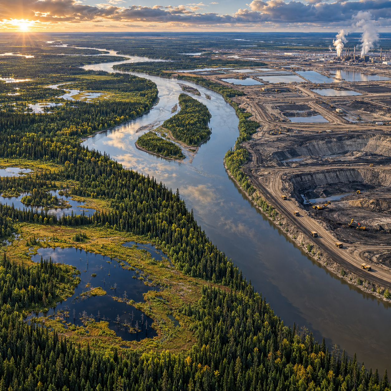
Alberta’s oil sands lie within a vast boreal landscape of forests, rivers, wetlands and peatlands. Extraction and its supporting roads, pipelines and facilities can alter this connected system, affecting wildlife habitat, water use and the places people rely on. The scale and type of impact vary by project, so understanding the environmental concerns means looking at both documented changes and risks that require continued monitoring.
What and where are Alberta’s oil sands?
Alberta’s oil sands are deposits of bitumen, a dense form of petroleum, found mainly in the Athabasca, Cold Lake and Peace River regions. Projects use surface mining where deposits are close to the surface, and in-situ methods, which heat or otherwise mobilize bitumen underground, for deeper deposits.
The Athabasca region north of Fort McMurray is especially important because large surface mines and in-situ operations occupy or influence parts of the boreal forest and the Athabasca River watershed. In-situ projects generally disturb less land directly than large mines, but they still require well pads, roads, pipelines, processing facilities and water management systems. Their impacts are therefore different, not absent.
Oil sands development also depends on infrastructure beyond extraction sites. Access roads and power lines can open remote areas to further activity, while pipelines connect production to processing and transportation networks. Looking at one lease alone can miss cumulative effects across a watershed or wildlife range.
How development changes the boreal landscape
Oil sands development changes boreal habitat through land clearing, industrial infrastructure and the fragmentation of once-connected forest. Surface mining removes vegetation and soil across mine areas, while roads, seismic lines and well pads divide habitat across both mining and in-situ landscapes.
Fragmentation matters because wildlife needs more than patches of trees. Caribou, for example, depend on large areas of suitable habitat and can be affected when industrial access routes make it easier for predators to move through a landscape. Other species may lose nesting, feeding or migration areas. Noise, traffic and human activity can also change how animals use the remaining habitat.
Wetlands and peatlands are a key part of this picture. They store water, support specialized plants and animals, and in peatlands hold large amounts of carbon in waterlogged soils. Clearing, drainage, roads and changes to surface or groundwater flows can alter wetland conditions. The extent and persistence of those effects depend on the project, local hydrology and the effectiveness of controls.
Reclamation plans aim to rebuild landforms and vegetation after disturbance, but restoring a functioning ecosystem takes time. A young planted forest is not immediately equivalent to old forest, and recreating peatland hydrology and ecological relationships can be particularly challenging. This is why the area disturbed, the quality of remaining habitat and the pace of recovery all matter.
What oil sands operations mean for water
Oil sands operations use and manage water from sources that include the Athabasca River and groundwater, depending on the project and its approvals. Water risks include changes to flow, disturbance of watershed drainage and the possibility of pollutants entering water or soil; the pathways and level of risk differ among operations.
Surface mining uses water in bitumen extraction and produces tailings, a mixture that includes water, fine sediment, residual bitumen and process chemicals. Companies store these materials in engineered tailings ponds. In-situ operations typically have a different water profile, often involving underground steam generation and management of produced water. It is misleading to treat every project as having the same water use or waste stream.
For the Athabasca River, water withdrawals are regulated and monitored, with requirements intended to manage withdrawals in relation to river conditions. That oversight is important, but it does not make scrutiny unnecessary. Seasonal low flows, climate change and cumulative demands across users all shape questions about how much water is available and when.
Water quality monitoring also needs careful interpretation. Researchers and regulators examine water, sediment, air deposition and other possible pathways to assess whether contaminants are naturally occurring, linked to industrial activity, or affected by both. A measured substance alone does not establish its source or the level of harm. Strong monitoring uses consistent methods, transparent data and independent review, especially where communities depend on the watershed.
A watershed is the land area that drains into a shared river, lake or stream. What happens on cleared land, in wetlands or beside tributaries can affect water movement and quality downstream, which is why project-level assessments should be considered alongside the health of the broader basin.
Tailings ponds, reclamation, and long-term concerns
Tailings ponds hold waste material produced by surface mining, and reclamation aims to return disturbed areas to stable landforms and functioning ecosystems. The central long-term concern is whether these outcomes can be achieved at the scale, pace and ecological quality promised.
Tailings contain water, fine particles and residual materials from processing. They require long-term containment and management. Questions include how quickly fine particles settle, how water can be treated or reused, and how risks are controlled during operation and after closure. These are technical and regulatory challenges, not evidence that every pond will fail; equally, a plan to manage tailings is not proof that long-term impacts have been eliminated.
Reclamation can involve reshaping disturbed land, replacing soil, planting vegetation and managing water so that land can support future uses. In Alberta, reclamation certification depends on regulatory requirements and evidence that specified outcomes have been met. Reaching a certified condition does not necessarily mean the area has returned to its original ecosystem or that every ecological function has recovered.
Assessment should distinguish between a company’s proposed plan, work completed on the ground and measured results over time. Useful questions include: What landform is being created? Which native species are returning? Is the water system functioning as intended? How will performance be checked after closure? These details turn broad promises into outcomes that citizens and regulators can evaluate.
Why Indigenous rights and community perspectives matter
Indigenous rights and community perspectives matter because changes to land and water can affect livelihoods, cultural practices, health and relationships with places used across generations. Decisions about oil sands development therefore involve more than technical estimates of disturbed area or water volume.
First Nations and Métis communities are diverse, and their views on particular projects should not be treated as interchangeable. Many communities have raised concerns about cumulative effects, access to traditional lands, wildlife, water quality and the ability to exercise rights. Their knowledge of local ecosystems can also add context that short-term studies or narrow project boundaries may miss.
Consultation and participation need to be meaningful, timely and connected to decisions. Residents and rights holders should be able to understand proposed effects, examine monitoring information and raise concerns through processes that can influence project conditions. For readers following a specific proposal, look for the affected communities’ own statements and avoid assuming that one spokesperson or organization represents everyone.
Community experience does not replace scientific monitoring, and technical reports do not replace lived knowledge or legal obligations. Sound oversight takes both seriously and makes clear what is known, what remains uncertain and who is responsible for acting when problems emerge.
What citizens can do to support informed oversight
Citizens can support informed oversight by following project decisions, reading monitoring results and taking part in public processes before key deadlines. A focused review of project documents is often more useful than relying on a single headline or broad claim.
- Track approvals and assessments: Check Alberta’s environmental assessment and regulatory information for project proposals, approval conditions, public notices and opportunities to comment. Note submission deadlines and the specific questions regulators are asking.
- Read monitoring data in context: Look for sampling locations, dates, methods and comparison points. A trend over time and across sites is usually more informative than an isolated result.
- Follow watershed information: Review river-flow and water-quality reporting from government and other credible monitoring programs. The Government of Alberta’s environmental monitoring and science resources provide a starting point for finding provincial information.
- Listen to affected communities: Seek out public statements and information from local Indigenous governments and community organizations, while recognizing that perspectives may differ.
- Make specific submissions: Refer to a proposed location, approval condition, monitoring gap or cumulative effect. Ask what evidence would trigger additional safeguards, and how those safeguards will be enforced.
Advocacy is strongest when it is precise. Instead of claiming that every oil sands operation creates the same impact, identify the project, pathway and evidence at issue. Citizens can ask whether a predicted effect is being monitored, whether results are publicly available, and what happens if actual conditions differ from the assessment. That approach keeps attention on accountability while respecting the complexity of Alberta’s boreal forest and watersheds.